Is Maspeth Safe? Queens Livability, Crime & Rent
Maspeth scores 5: a low crime rate and few housing violations, but weak transit and sparse trees.
For the borough-wide trend and the spread between police precincts, see Is Queens safe?

Maspeth at a glance
- Borough
- Queens
- Livability score (excludes crime)
- 5/10
- Livability rank (NYC Open Data guides)
- #25 of 27
- Safety verdict
- Safer Than Average
- Crimes (12 mo)
- 1,723
- ZIP codes
- 11378 (88%), 11379 (9%)Share of residential units, NYC PLUTO 26v2
- Subway stations
- 0
- Data updated
- 2026-09-14
Is Maspeth Safe?
By NYPD data, Maspeth is rated "Safer Than Average" for crime, with a lower crime rate per resident than 62% of Queens neighborhoods (39.8 reported crimes per 1,000 residents). It recorded 1,723 crime incidents and 1 shooting incident in the 12 months ending June 2026. Maspeth crime rate and NYPD breakdown →
Maspeth, Queens scores 5/10 for overall livability, ranking #25 of 27 Queens neighborhoods scored from NYC Open Data. Maspeth scores 5: a low crime rate and few housing violations, but weak transit and sparse trees.
The livability score draws on HPD housing violations, subway access, NYC Parks' tree inventory and parks, and 311 noise complaints per resident from NYC Open Data, refreshed periodically rather than live. It does not include crime; NYPD complaint and shooting figures are on the Maspeth safety page. Safety varies by block — check a specific Maspeth address below for a block-level breakdown.
Maspeth ranks #22 of 59 Queens neighborhoods for reported crime near a typical spot (1 = fewest)
Mean NYPD complaints (every category) within 300 m of 100 random points in each residential 2020 NTA in Queens, 12 months ending June 30, 2026. Each shade holds about a fifth of them. Per area, not per resident, so the order can differ from the per-resident rate.
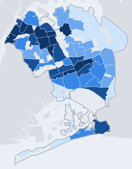
NYPD complaints within 300 m, 12 months to June 30, 2026

Outlined: Maspeth (QN0501), 92.2, #22. Rape and sex-crime complaints, which NYPD publishes at one point per precinct, are left out. All 59 ranked.
Source: NYPD Complaint Data via NYC Open Data (5uac-w243, qgea-i56i), pulled September 14, 2026; boundaries: 2020 Neighborhood Tabulation Areas (NTAs) (9nt8-h7nd).
Score Overview
Vertical line = borough median. Scale: 0-10.
Practical measures HPD housing violations per residential lot over the last 12 months (higher = fewer violations). Borough medians are computed across DwellCheck's Queens neighborhood guides.
Neighborhood Character
Maspeth offers a distinctly residential feel with a dominant presence of one- and two-family homes. You'll find 46% of residential tax lots are two-family homes and 35% are one-family homes. The area has a tree density of 1.4/10, with approximately 91 trees expected in a 200m circle, making it sparser than most NYC neighborhoods. While the area has 17 NYC Parks properties, including Frank Principe Park and Reiff Playground, limited transit options characterize the daily commute.
Advertisements
Livability & Restoration
Trees
91 trees
Expected in a 200m circle (NYC Parks tree inventory) | Density: 1.4/10 (city percentile)
In Toronto, 10 more trees on a city block went with a rise in self-rated health comparable to being 7 years younger (Kardan et al., 2015, Scientific Reports). In a cross-sectional study of London boroughs, each additional street tree per km of street went with 1.18 fewer antidepressant prescriptions per 1,000 residents (Taylor et al., 2015, Landscape and Urban Planning).
Park Access
17 parks
NYC Parks properties inside the neighborhood | largest: Frank Principe Park | nearest to the center: Park Slope, 207m | 3 nearest average 316m from the neighborhood's center
Acoustic Quality
5/10
Noise proxy score (higher = quieter)
Environmental noise exposure increases the occurrence of hypertension and cardiovascular disease; WHO's night-noise guidelines call average outdoor night noise above 55 dB increasingly dangerous for public health (Basner et al., 2014, The Lancet).
What is the ART Score?
ART stands for Attention Restoration Theory (Kaplan & Kaplan, 1989) — the framework environmental psychologists use to measure whether a place helps your brain recover from mental fatigue, or pushes it deeper into overload. Cities deplete directed attention (the effortful focus you use at work); exposure to restorative environments replenishes it.
DwellCheck uses the idea in two separate places, and they measure different things. The neighborhood ART score below comes from neighborhood-wide data: up to 5 points from tree density (a city percentile) and up to 5 from how few 311 noise complaints there are per resident. An address report has no ART score. It runs the Wellness checks below, and their points go into the address’s overall score.
More than a point below the Queens median: sparser trees, more noise complaints per resident, or both.
What an address report checks instead (Wellness)
- ±Sensory environment. A calm score minus a busy score, each starting at 50. Busy: a firehouse within 100m (+15) or 200m (+8), and 311 noise complaints within 200m over 6 months (15+ adds 5, 40+ adds 12, 80+ adds 20, and 3 more at 20+ complaints that include vehicle or street noise). Calm: a library (+15), community garden (+12) or public plaza or atrium (POPS; +15 indoor, +8 outdoor) within 200m, and a park within 300m (+10; +15 at 1+ acre; +20 at 5+ acres). A difference of +20 or more adds 8 points; −10 to −29 costs 2; −30 or less costs 4. Bars, museums, tourists and foot traffic are not counted.
- +Third places (Oldenburg, 1989). Public libraries, public plazas and atriums (POPS) and community gardens within 400m: 1–2 add 5 points, 3 or more add 10. Cafés and community centers are not counted. In a meta-analysis of longitudinal studies, loneliness or social isolation went with a 29% higher risk of incident coronary heart disease (Valtorta et al., 2016, Heart).
- 0Street vitality (Jacobs, 1961). Permitted block parties, farmers markets and similar community events in the borough over the past 12 months. The event data has no coordinates, so this is a borough-wide count shown for context. It doesn’t change the score.
Health mechanism. The theory holds that natural settings let directed attention recover. The evidence is mixed: a systematic review of 31 studies (Ohly et al., 2016, Journal of Toxicology and Environmental Health, Part B) found that time in natural environments improved 3 of 13 pooled attention measures (Digit Span Forward, Digit Span Backward and Trail Making Test B) and showed no marked benefit on the other 10.
Theoretical foundations. Kaplan & Kaplan (1989), The Experience of Nature; Jacobs (1961), The Death and Life of Great American Cities; Oldenburg (1989), The Great Good Place.
Maspeth ranks #17 of 59 Queens neighborhoods for 311 noise complaints (1 = quietest), with a median of 0 rodent complaints near a typical spot
Median 311 complaints within 100 m (noise) and 150 m (rodents) of 100 random points in each residential 2020 NTA in Queens, noise March 13, 2026 to September 13, 2026, rodents March 17, 2026 to September 13, 2026. Noise shades hold about a fifth each; rodent shades break at 1, 2. Complaints filed, not measured sound or a count of rats.
Noise
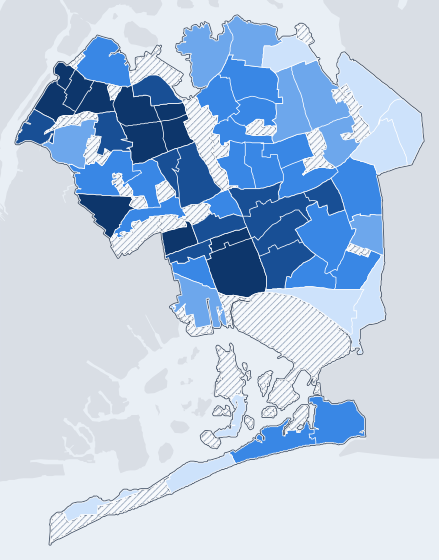
Noise complaints within 100 m (median)

Rodents
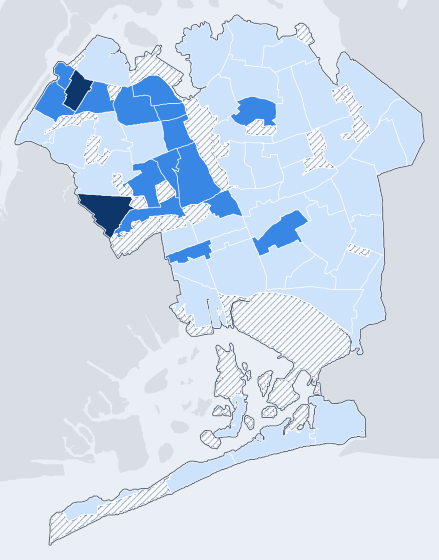
Rodent complaints within 150 m (median)

Outlined: Maspeth, noise 2 (#17), rodents 0. Quietest Queens neighborhoods.
Source: NYC 311 Service Requests via NYC Open Data (erm2-nwe9), pulled September 14, 2026; boundaries: 2020 Neighborhood Tabulation Areas (NTAs).
Transit & Commute
Subway Stations
No transit data available
Commute Score
1/10
Borough median: 3.5/10
Outdoor & Green Space
Avg Tree Count
91
Trees expected in a 200m circle
Tree Density
1.4/10
723 trees per km² in NYC Parks' tree inventory (street and park trees); city percentile, 1 = sparsest
Largest Parks In or Near the Neighborhood
- Frank Principe Park
- Reiff Playground
- Frontera Park
- Whitefish Triangle
- Sitting Area 127 CXXVII
Nearest to the neighborhood's center: Park Slope, about 207m. The 3 nearest NYC Parks properties average 316m from the center (approximate park centers, not entrances).

Practical Living
Practical (HPD violations): 9/10 (Queens median 8). It measures HPD housing violations per residential lot over the last 12 months (higher = fewer violations).
Building Mix (Residential Tax Lots)
Share of the 8,057 residential tax lots in the neighborhood by PLUTO building class (NYC Department of City Planning).
Advertisements
Who Maspeth Is For
Families seeking quiet
You'll find a quieter environment with Low noise complaints (36.5 per 1,000 residents) and a safer than average crime verdict.
Residents prioritizing safety
The neighborhood is safer than average, with a lower crime rate per resident than 62% of Queens neighborhoods.
Those preferring detached housing
With 46% of residential tax lots as two-family homes and 35% as one-family homes, you'll find a prevalence of house-style living.
Pros & Cons
Strengths
Safer than average
The neighborhood is safer than average, with a lower crime rate per resident than 62% of Queens neighborhoods.
Low noise complaints
You'll find 1577 noise complaints in the last 12 months, which is 36.5 per 1,000 residents, labeled as Low.
Well-maintained housing
The Practical score is 9, indicating fewer HPD housing violations per residential lot than the borough median of 8.
Trade-offs
Limited transit options
The Commute score is 1, lower than the borough median of 3.5, indicating limited transit access.
Sparser tree density
The tree density is 1.4/10, making it sparser than most NYC neighborhoods, and the ART/Livability score is 2.7, lower than the borough median of 4.1.
Worsening crime trend
Total crimes increased by 6.3% in the last 12 months.
Score Any Address in Maspeth
Get detailed livability scores based on building health, transit access, safety, noise levels, and 15+ NYC data sources.
Search an Address in MaspethFrequently Asked Questions about Maspeth
1Is Maspeth safe?
By NYPD data, Maspeth is rated "Safer Than Average" for crime, with a lower crime rate per resident than 62% of Queens neighborhoods (39.8 reported crimes per 1,000 residents). It recorded 1,723 crime incidents and 1 shooting incident in the 12 months ending June 2026. See the safety page for the full breakdown.
2What is the average rent in Maspeth?
Rents in Maspeth, Queens vary significantly by building and apartment type. Market pricing isn't aggregated for this neighborhood yet; use DwellCheck to research specific addresses for HPD registration, HPD violations, and other building-level records. DwellCheck doesn't show rent-stabilization status; request the apartment's rent history from DHCR for that.
3How is transit access in Maspeth?
Maspeth has a commute score of 1/10. It counts the subway stations inside the neighborhood and the lines they serve. Station-level mapping for this neighborhood isn't available yet.
4What are the best streets in Maspeth?
The best streets depend on your priorities. Use DwellCheck to compare specific addresses across livability, safety, transit, and environmental factors.
5What is Maspeth known for?
Maspeth sits in Queens and ranks #25 of 27 Queens neighborhoods scored from NYC Open Data on DwellCheck's livability score (5/10). It's served by 0 subway stations. Maspeth scores 5: a low crime rate and few housing violations, but weak transit and sparse trees.
6What is it like to live in Maspeth?
DwellCheck scores Maspeth, Queens from NYC Open Data on practical (HPD housing violations per residential lot over the last 12 months (higher = fewer violations)), commute (subway stations and lines in the neighborhood), ART (tree density and 311 noise complaints per resident), outdoor (trees and park proximity). Maspeth's composite is 5/10. Maspeth scores 5: a low crime rate and few housing violations, but weak transit and sparse trees. For the block-by-block view, run any specific Maspeth address through DwellCheck.
7Where is Maspeth?
Maspeth is in Queens, New York City. DwellCheck maps it to the Maspeth Neighborhood Tabulation Area (QN0501), which falls in the Census tabulation area that approximates Queens Community District 5 (Ridgewood-Maspeth-Middle Village). Its main ZIP codes are 11378 and 11379.
8What ZIP code is Maspeth in?
Maspeth spans ZIP codes 11378 (88% of residential units) and 11379 (9%). Shares are of the 15,510 residential units in the Maspeth Neighborhood Tabulation Area (QN0501), from NYC PLUTO 26v2 tax-lot records. 3 other ZIP codes each hold under 5%.
9Can you walk around Maspeth at night?
Maspeth is classified as "Safer Than Average" by NYPD complaint data. Over the past 12 months it recorded 1 shooting incident and 1,723 total crime incidents. Walking at night carries the same risk profile as anywhere in NYC: stay on commercial corridors with foot traffic, avoid empty side streets after midnight, and prefer subway lines that run 24/7.
10Is Maspeth dangerous?
By NYPD data, Maspeth is rated "Safer Than Average", with a lower crime rate per resident than 62% of Queens neighborhoods. 1,723 crime incidents over 12 months. Block-level risk varies; check the address-level safety score for any specific street or building.
11What parts of Maspeth should I avoid?
NYPD complaint records carry approximate incident coordinates, but a neighborhood total can't tell you which blocks drive it, so we don't publish an "avoid this street" list. For a specific block, use DwellCheck's address-level safety score, which counts NYPD crime complaints within a 300m radius of the building over the latest 12 months of published data and compares that count with the borough average.
12Is Maspeth a good place to live?
Maspeth scores 5/10 for overall livability and has a lower crime rate per resident than 62% of Queens neighborhoods. Maspeth scores 5: a low crime rate and few housing violations, but weak transit and sparse trees. Whether it's a good fit depends on what you weight: families, solo renters, and remote workers each prioritize different factors (noise, transit access, parks, building quality).
13What is the average DwellScore in Maspeth?
Maspeth has a Composite DwellScore of 5. This score is influenced by a strong Practical score of 9 and a low Commute score of 1.
14How does Maspeth rank for quietness and green space?
Maspeth has an ART/Livability score of 2.7, which is below the Queens borough median of 4.1. This is due to a tree density of 1.4/10 and Low noise complaints.
15What is the transit situation in Maspeth?
Maspeth has a Commute score of 1, which is below the Queens borough median of 3.5, indicating limited transit options.
16Is Maspeth a safe neighborhood?
Maspeth is safer than average, with a lower crime rate per resident than 62% of Queens neighborhoods. However, the crime trend is worsening, with a 6.3% increase in total crimes over 12 months.
Related Guides
NYC Building Complaints Lookup
Check any building's HPD, DOB, and 311 complaint history before signing.
30 NYC Apartment Red Flags
What to watch for at the viewing, in the listing, and on the landlord.
How to Check Your NYC Landlord
A 5-step free lookup: ACRIS ownership, HPD violations, DOB complaints, lawsuits.
Is My Apartment Rent-Stabilized?
Request a free DHCR rent history and verify stabilization status in 24-72 hours.