Is Harlem Safe? Manhattan Livability, Crime & Rent
Harlem scores a 6.3 median composite: strong on practical logistics and green space, weak on safety trends and noise, neutral on financial and investment fundamentals.
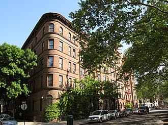
Harlem at a glance
- Borough
- Manhattan
- Livability score
- 6.3/10
- Borough rank
- #21 of 33
- Safety verdict
- Higher Than Average
- Crimes (12 mo)
- 12,684
- Median listing
- $0
- Subway stations
- 2 (110 St, 103 St)
- Active listings
- 1,076
- Data updated
- 2026-04-05
Is Harlem Safe?
Harlem, Manhattan scores 6.3/10 for overall livability, ranking #21 of 33 Manhattan neighborhoods. Harlem scores a 6.3 median composite: strong on practical logistics and green space, weak on safety trends and noise, neutral on financial and investment fundamentals.
This score aggregates live NYPD crime data, 311 safety complaints, shooting incidents, and building health signals within walking distance. Safety varies by block — check a specific Harlem address below for a block-level breakdown.
Score Overview
Vertical line = borough median. Scale: 0-10.
Neighborhood Character
You'll find yourself in a neighborhood dense with street trees—averaging 79 within a 200-meter radius with 9.5/10 canopy density—that softens the midrise building fabric dominating the streetscape. The area clusters around two major transit hubs (110 St and 103 St stations on the 6 line), making it a throughway that feels animated and in motion. Five parks anchor different blocks: Marcus Garvey Park, Thomas Jefferson Park, Harlem River Park, Louis Cuvillier Louis Cuvillier Park, and Triboro Plaza sit an average of 154 meters away, offering green relief across the neighborhood. The sound profile is notably active—17,169 noise complaints filed over 12 months reflect a high-density, high-traffic environment where street noise and sirens are ambient facts of daily life.
Analysis based on 1076 properties scored across 30+ data points

Livability & Restoration
Tree Canopy
79 trees
Avg within 200m | Density: 9.5/10
10 additional trees per block correlates with health benefits equivalent to being 7 years younger (Kardan et al., 2015)
Park Access
Marcus Garvey Park
Avg 154m away | Score: 3/10
Living within 300m of green space associated with 30% fewer antidepressant prescriptions (Taylor et al., 2015)
Acoustic Quality
10/10
Noise proxy score (higher = quieter)
Chronic noise above 55 dB at night associated with 8% cardiovascular mortality increase (Basner et al., 2014)
Street Character
0/10
Enclosure: 0/10
What is the ART Score?
ART stands for Attention Restoration Theory (Kaplan & Kaplan, 1989) — the framework environmental psychologists use to measure whether a place helps your brain recover from mental fatigue, or pushes it deeper into overload. Cities deplete directed attention (the effortful focus you use at work); exposure to restorative environments replenishes it.
We compute an ART score for every block by combining four signals: access to restorative zones (parks, museums, libraries), sensory load (nightlife and tourist density), street vitality (Jane Jacobs’ “eyes on the street”), and third places (Oldenburg’s informal community spaces).
In line with the Manhattan median — typical city stimulus with typical restorative access.
What drives the score
- +Restorative zones. Museums, libraries, community gardens, and parks within walking distance. “Soft fascination” stimuli (clouds, tree branches, water) let directed attention recover without effort — the Kaplans’ core mechanism.
- −Sensory load. Bar and nightclub density (5+ within 150m), firehouse siren corridors, tourist chokepoints, and very high foot traffic push the score down by up to 8 points.
- +Street vitality (Jacobs, 1961). Permitted block parties, farmers markets, and community festivals over the past 12 months — a proxy for “eyes on the street” and the informal surveillance that makes blocks feel safe and maintained.
- +Third places (Oldenburg, 1989). Cafés, public plazas (POPS), community centers — the “anchors of community life” that buffer against social isolation. Loneliness has been linked to 29% higher incident coronary heart disease risk (Valtorta et al., 2016).
Health mechanism. Directed-attention fatigue (DAF) is linked to impaired decision-making, irritability, and elevated cortisol. A meta-analysis of 60+ studies (Ohly et al., 2016) found restorative environment exposure significantly improves attention-task performance (Hedges’ g ≈ 0.32) and reduces negative affect.
Theoretical foundations. Kaplan & Kaplan (1989), The Experience of Nature; Jacobs (1961), The Death and Life of Great American Cities; Oldenburg (1989), The Great Good Place.

Transit & Commute
Subway Stations
Commute Score
5/10
Borough median: 8.5/10
Walk Score Proxy
0/10
Based on street geometry analysis

Financial Landscape
Median Price
$0
Price per Sq Ft
$0
Price Distribution
Price by Building Type

Investment Indicators
Avg Unused FAR
0 sqft
Development rights potential
Unused development rights valued at $30-$80/sqft in Brooklyn (Glaeser, 2011)
Avg Days on Market
0
Market velocity signal
Multi-Family Stock
0%
2-4 family buildings
Multi-family owner-occupants build 2.4x wealth vs single-family (Herbert, 2013)

Outdoor & Green Space
Avg Tree Count
79
Within 200m radius
Canopy Density
9.5/10
Normalized canopy coverage
Park Network
- Marcus Garvey Park
- Thomas Jefferson Park
- Harlem River Park
- Louis Cuvillier Park
- Triboro Plaza
Avg distance: 154m

Practical Living
Building Types
Who Harlem Is For
Transit-dependent commuters
Direct 6 line access at two stations with practical infrastructure score of 9—the highest metric in your profile—makes navigating without a car straightforward and efficient
People prioritizing outdoor access
Outdoor score of 6 combined with exceptional tree coverage (79 avg per 200m) and five nearby parks puts green space above borough median (4.2)
Those accepting trade-offs for cultural anchors
Established cultural institutions and affordable housing stock draw residents willing to accept high noise (17,169 complaints) and safety volatility (crime +205.6% trend)
Pros & Cons
Strengths
Exceptional tree canopy and park access
79 trees average within 200m with 9.5/10 canopy density; five parks within 154m average, outperforming borough outdoor score of 4.2
Strong transit connectivity
Two subway stations (110 St, 103 St on the 6 line) with practical score of 9—highest metric and well above borough median of 5.8
Stable mid-rise building stock
1,076 tracked buildings predominantly mid-rise (75%) and high-rise (20%), providing consistent residential infrastructure
Trade-offs
Very high noise environment
17,169 noise complaints over 12 months indicate sustained street-level activity and limited sound insulation expectations
Worsening crime trend
9,504 total crimes in 12 months with +205.6% trend increase signals deteriorating safety dynamics despite percentile ranking at 47% (mid-range for borough)
Weak commute score despite transit access
Commute score of 5 is significantly below borough median of 8.5, suggesting commute times or transfers remain problematic despite station presence
Score Any Address in Harlem
Get detailed livability scores based on building health, transit access, safety, noise levels, and 15+ NYC data sources.
Search an Address in HarlemFrequently Asked Questions about Harlem
1Is Harlem safe?
By NYPD data, Harlem is rated "Higher Than Average" — safer than 30% of Manhattan neighborhoods. 12,684 crime incidents and 24 shooting incidents over the past 12 months. See the safety page for the full breakdown.
2What is the average rent in Harlem?
Rents in Harlem, Manhattan vary significantly by building and apartment type. The median listing price is $0. Use DwellCheck to research specific addresses.
3How is transit access in Harlem?
Harlem has a commute score of 5/10. 2 subway stations serve the area: 110 St, 103 St.
4What are the best streets in Harlem?
The best streets depend on your priorities. Use DwellCheck to compare specific addresses across livability, safety, transit, and environmental factors.
5What is Harlem known for?
Harlem sits in Manhattan and ranks #21 of 33 Manhattan neighborhoods on DwellCheck's livability score (6.3/10). It's served by 2 subway stations (110 St, 103 St), with a median listing price of $0. Harlem scores a 6.3 median composite: strong on practical logistics and green space, weak on safety trends and noise, neutral on financial and investment fundamentals.
6What is it like to live in Harlem?
Living in Harlem, Manhattan weights against six livability dimensions: practical (HPD-violation density), commute (subway proximity), arts/culture (venue density), outdoor (parks + trees), financial (price level), investment (price trend). Harlem's composite is 6.3/10. Harlem scores a 6.3 median composite: strong on practical logistics and green space, weak on safety trends and noise, neutral on financial and investment fundamentals. For the block-by-block view, run any specific Harlem address through DwellCheck.
7Is Harlem expensive?
Median listing price in Harlem, Manhattan is $0 based on 1,076 active listings as of 2026-04-05. Whether that reads "expensive" depends on the comparison: it's lower than Manhattan averages and varies considerably by building. Rent-stabilized units in Harlem can run 20-40% below the median; check DHCR rent history for any specific address to verify.
8Can you walk around Harlem at night?
Harlem is classified as "Higher Than Average" by NYPD CompStat data. Over the past 12 months it recorded 24 shooting incidents and 12,684 total crime incidents. Walking at night carries the same risk profile as anywhere in NYC: stay on commercial corridors with foot traffic, avoid empty side streets after midnight, and prefer subway lines that run 24/7.
9Is Harlem dangerous?
By NYPD data, Harlem is rated "Higher Than Average" — safer than 30% of Manhattan neighborhoods. 12,684 crime incidents over 12 months. Block-level risk varies; check the address-level safety score for any specific street or building.
10What parts of Harlem should I avoid?
NYPD CompStat reports incidents at the precinct level, not block-by-block, so a granular "avoid this street" answer isn't possible from public data alone. The most reliable signal at the block level is DwellCheck's address-level safety score, which weights NYPD incidents within a 250m radius of a specific building. As a general rule across NYC: industrial blocks with no foot traffic are higher-risk than residential blocks; subway-station-adjacent commercial corridors are lowest-risk.
11Is Harlem a good place to live?
Harlem scores 6.3/10 for overall livability and ranks in the 30th percentile for safety in Manhattan. Harlem scores a 6.3 median composite: strong on practical logistics and green space, weak on safety trends and noise, neutral on financial and investment fundamentals. Whether it's a good fit depends on what you weight: families, solo renters, and remote workers each prioritize different factors (noise, transit access, parks, building quality).
12What is the average DwellScore in Harlem?
Median composite score is 6.3 (interquartile range 5.9–6.7). Your practical infrastructure and outdoor access pull the score up; commute dynamics and safety volatility pull it down.
13Is Harlem safe?
Safety percentile ranks at 47% within the borough—median territory—but the trend is concerning: crimes increased 205.6% over 12 months. High noise complaints (17,169) and elevated rodent complaints (1,276) reflect neighborhood stress points.
14How accessible is public transit?
You have direct access to the 6 line at 110 St and 103 St stations. Practical score of 9 is highest in your profile, but commute score of 5 (vs. borough median 8.5) suggests actual commute times may still be long depending on destination.
15What's the outdoor and green space situation?
Outdoor score of 6 beats borough median of 4.2. You'll average 79 trees within 200m with 9.5/10 canopy density, and five parks (Marcus Garvey, Thomas Jefferson, Harlem River, Louis Cuvillier, Triboro Plaza) sit roughly 154m away on average.
Related Guides
NYC Building Complaints Lookup
Check any building's HPD, DOB, and 311 complaint history before signing.
30 NYC Apartment Red Flags
What to watch for at the viewing, in the listing, and on the landlord.
How to Check Your NYC Landlord
A 5-step free lookup: ACRIS ownership, HPD violations, DOB complaints, lawsuits.
Is My Apartment Rent-Stabilized?
Request a free DHCR rent history and verify stabilization status in 24-72 hours.